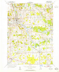
1954 Map of Milford
USGS Topo · Published 1955About this map
Milford serves as a focal point on this mid-century survey, situated along the Huron River and dominated by water-driven industrial markers like the Upper Mill Pond and Lower Mill Pond. The landscape of southwestern Oakland County is defined by its glaciated terrain, featuring a high density of water bodies such as Proud Lake, Wolverine Lake, and Loon Lake. The rail infrastructure of the Chesapeake and Ohio railroad cuts diagonally across the township, connecting the village to New Hudson in the south. Aviation interests are visible via the New Hudson Airport and Spencer Landing Field, while the nascent recreational development of Kensington Metropolitan Park and Proud Lake State Recreation Area suggests the area's transition toward a regional leisure destination for nearby growing populations.
Find a feature on this map
55 named features on this map. Tap any name to fly to it.
Don’t see what you’re looking for? This feature index may not catch every label — zoom into the map to look around manually.
Map Details
Editions of this 1954 Milford Map
This is the sole edition of this map. No revisions or reprints were ever made.
Other maps of this area

1902 · South Lyon
USGS Topo · 1:62,500

1904 · Ann Arbor
USGS Topo · 1:125,000

1905 · Wayne
USGS Topo · 1:62,500

1906 · South Lyon
USGS Topo · 1:62,500

1907 · Pontiac
USGS Topo · 1:62,500

1908 · Ann Arbor
USGS Topo · 1:125,000

1909 · Milford
USGS Topo · 1:62,500

1912 · Wayne
USGS Topo · 1:62,500

1936 · Wixom
USGS Topo · 1:31,680

1936 · Highland
USGS Topo · 1:31,680
Featured Places
- Novi, MI
- Commerce Charter Township, MI
- White Lake Charter Township, MI
- Lyon Charter Township, MI
- Highland Charter Township, MI