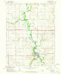
1964 Map of Milford
USGS Topo · Published 1965About this map
The Big Blue River meanders south through Seward County, anchoring the town of Milford and its surrounding agricultural landscape. This mid-century survey captures a significant moment in regional transportation, with Interstate 80 shown as under construction across the center of the sheet, poised to reshape local travel. The Chicago Burlington and Quincy railroad line follows the river valley, passing through the settlement of Ruby and serving the industrial and educational needs of the area.
Find a feature on this map
35 named features on this map. Tap any name to fly to it.
Don’t see what you’re looking for? This feature index may not catch every label — zoom into the map to look around manually.
Map Details
Editions of this 1964 Milford Map
2 editions found
Other maps of this area

1897 · Lincoln
USGS Topo · 1:125,000

1934 · Seward
USGS Topo · 1:48,000

1935 · Dorchester
USGS Topo · 1:48,000

1939 · Seward
USGS Topo · 1:62,500

1940 · Dorchester
USGS Topo · 1:62,500

1955 · Lincoln
USGS Topo · 1:250,000

1957 · Lincoln
USGS Topo · 1:250,000

1958 · Lincoln
USGS Topo · 1:250,000
1964 · Staplehurst
USGS Topo · 1:24,000
1964 · Goehner
USGS Topo · 1:24,000