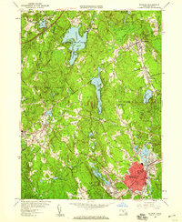
1953 Map of Milford
USGS Topo · Published 1959About this map
Industrial and residential development centers on the town of Milford, where a dense network of streets like Purchase St and Congress St surround landmarks such as the Armory and St Marys. The landscape transitions from the urban core of Milford and nearby Hopedale to the expansive woodland of Upton State Forest and Whitehall State Forest. These protected lands, along with the Wildlife Research Center, preserve the area's natural hydrology, including Whitehall Reservoir and North Pond.
Find a feature on this map
69 named features on this map. Tap any name to fly to it.
Don’t see what you’re looking for? This feature index may not catch every label — zoom into the map to look around manually.
Map Details
Editions of this 1953 Milford Map
4 editions found
Other maps of this area

1886 · Blackstone
USGS Topo · 1:62,500

1886 · Framingham
USGS Topo · 1:62,500

1887 · Franklin
USGS Topo · 1:62,500

1887 · Marlboro
USGS Topo · 1:62,500

1889 · Marlboro
USGS Topo · 1:62,500

1889 · Blackstone
USGS Topo · 1:62,500

1889 · Franklin
USGS Topo · 1:62,500

1889 · Framingham
USGS Topo · 1:62,500

1893 · Franklin
USGS Topo · 1:62,500

1893 · Blackstone
USGS Topo · 1:62,500