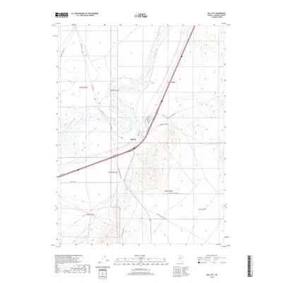
2018 Map of Mill City
USGS Topo · Published 2018About this map
Mill City sits at a critical junction in Pershing County where the Humboldt River and modern transport corridors meet the basin-and-range topography. The landscape is defined by its water management and transit history, visible in the Pitt-Taylor Diversion Canal and the historic route of the Old Idaho Stage Rd. The intersection of industrial utility and desert geography is clear, with Tungsten Rd leading toward the mountains while the Humboldt River meanders through the central valley. To the east, the terrain rises into several canyons, including Dun Glen Canyon Rd and Stonehouse Canyon Rd, which lead away from the expansive Dun Glen Flat. This 2018 survey captures the region's enduring character as a transit hub, maintaining the spatial relationships of ranching roads like Willow Creek Ranch Rd and early pioneers' trails.
Find a feature on this map
24 named features on this map. Tap any name to fly to it.
Don’t see what you’re looking for? This feature index may not catch every label — zoom into the map to look around manually.
Map Details
Editions of this 2018 Mill City Map
This is the sole edition of this map. No revisions or reprints were ever made.
Other maps of this area

1931 · Lovelock
USGS Topo · 1:250,000

1932 · Sonoma Range
USGS Topo · 1:250,000

1935 · Lovelock
USGS Topo · 1:250,000

1939 · Sonoma Range
USGS Topo · 1:250,000

1939 · Eugene Mountains Area
USGS Topo · 1:62,500

1942 · Eugene Mountains Area
USGS Topo · 1:62,500

1955 · Lovelock
USGS Topo · 1:250,000

1955 · Winnemucca
USGS Topo · 1:250,000

1956 · Imlay
USGS Topo · 1:62,500

1958 · Winnemucca
USGS Topo · 1:250,000