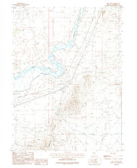
1987 Map of Mill City
USGS Topo · Published 1987About this map
Mill City serves as a focal point along the Southern Pacific rail line in this Nevada desert landscape, where water management and mineral extraction define the local economy. The winding Humboldt River is closely paralleled by the Pitt-Taylor Canal, illustrating the engineering efforts required to divert water for local use. To the south, the foothills of the Humboldt Range rise sharply, dotted with numerous Prospect sites that reflect the region's enduring mining heritage. The map also captures infrastructure such as a Landing Strip and a Trailer Park, alongside broad topographical features like Dun Glen Flat and its namesake Dun Glen Creek. This 1980s data provides a clear view of how transportation and irrigation networks converged in Pershing County, supporting both transit and small-scale settlement.
Find a feature on this map
18 named features on this map. Tap any name to fly to it.
Don’t see what you’re looking for? This feature index may not catch every label — zoom into the map to look around manually.
Map Details
Editions of this 1987 Mill City Map
This is the sole edition of this map. No revisions or reprints were ever made.
Other maps of this area

1931 · Lovelock
USGS Topo · 1:250,000

1932 · Sonoma Range
USGS Topo · 1:250,000

1935 · Lovelock
USGS Topo · 1:250,000

1939 · Sonoma Range
USGS Topo · 1:250,000

1939 · Eugene Mountains Area
USGS Topo · 1:62,500

1942 · Eugene Mountains Area
USGS Topo · 1:62,500

1955 · Lovelock
USGS Topo · 1:250,000

1955 · Winnemucca
USGS Topo · 1:250,000

1956 · Imlay
USGS Topo · 1:62,500

1958 · Winnemucca
USGS Topo · 1:250,000