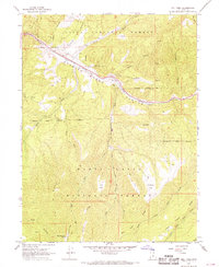
1967 Map of Mill Fork
USGS Topo · Published 1969About this map
Spanish Fork Canyon serves as the primary corridor for transportation and water through this high-altitude landscape in the late 1960s. The Denver and Rio Grande Western railroad tracks parallel Soldier Creek, winding through the Narrows past the settlement of Mill Fork. The terrain is defined by the intersection of the Uinta National Forest and the Manti-La Sal National Forest, where a network of drainage systems like Dairy Fork and Clear Creek carve out deep canyons and ridges. Land use in this era is signaled by infrastructure such as a Quarry, Gravel Pit, and various jeep trails and pack trails accessing remote sites like Terry Flat and Mountain Lion Spring. The map captures a moment when the rugged logistics of the railroad and canyon access were central to the area's geography.
Find a feature on this map
36 named features on this map. Tap any name to fly to it.
Don’t see what you’re looking for? This feature index may not catch every label — zoom into the map to look around manually.
Map Details
Editions of this 1967 Mill Fork Map
This is the sole edition of this map. No revisions or reprints were ever made.
Other maps of this area

1885 · Salt Lake
USGS Topo · 1:250,000

1885 · Manti
USGS Topo · 1:250,000

1895 · Manti
USGS Topo · 1:250,000

1907 · Strawberry Valley
USGS Topo · 1:125,000

1909 · Strawberry Valley
USGS Topo · 1:125,000

1939 · Soldier Summit
USGS Topo · 1:62,500

1942 · Soldier Summit
USGS Topo · 1:62,500

1954 · Salt Lake City
USGS Topo · 1:250,000

1956 · Price
USGS Topo · 1:250,000

1958 · Salt Lake City
USGS Topo · 1:250,000