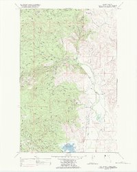
1989 Map of Mill Pocket Creek
USGS Topo · Published 1989About this map
The Flathead Indian Reservation dominates this 1980s landscape, where the managed waters of the Camas Canal and Alder Creek Ditch cut across the natural drainage of the Little Bitterroot River. The terrain is defined by dramatic elevation changes, rising from the Lozeau Flats in the north toward the heights of Sullivan Hill. Water management is a primary theme of the region, anchored by the Upper Dry Fork Reservoir and several designated springs that supported ranching and irrigation in this part of Sanders County. For genealogists, the McKay Cem provides a specific point of historical interest amidst the forested boundaries of the Lolo National Forest. The map captures a moment when traditional water rights and modern irrigation infrastructure like the Dry Fork Creek system were central to the area's development.
Find a feature on this map
17 named features on this map. Tap any name to fly to it.
Don’t see what you’re looking for? This feature index may not catch every label — zoom into the map to look around manually.
Map Details
Editions of this 1989 Mill Pocket Creek Map
This is the sole edition of this map. No revisions or reprints were ever made.
Other maps of this area

1956 · Wallace
USGS Topo · 1:250,000

1960 · Wallace
USGS Topo · 1:250,000

1964 · Mill Pocket Creek
USGS Topo · 1:24,000
1964 · Kofford Ridge
USGS Topo · 1:24,000

1964 · Coney Peak
USGS Topo · 1:24,000

1964 · Hubbart Reservoir
USGS Topo · 1:24,000

1964 · Murr Peak
USGS Topo · 1:24,000

1964 · Lonepine
USGS Topo · 1:24,000
1964 · Bassoo Peak
USGS Topo · 1:24,000
1964 · Niarada
USGS Topo · 1:24,000