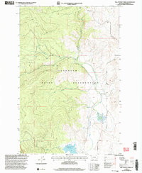
1999 Map of Mill Pocket Creek
USGS Topo · Published 2003About this map
The Flathead Indian Reservation dominates this 1990s terrain in Sanders County, where water management is central to the landscape. The Camas Canal and the Deer Creek Ditch highlight an intricate irrigation network designed to divert water across this high country. These man-made features work in tandem with natural drainages like Bassoo Creek and Mill Pocket Creek, which flow through the western mountains toward the Little Bitterroot River valley.
Find a feature on this map
16 named features on this map. Tap any name to fly to it.
Don’t see what you’re looking for? This feature index may not catch every label — zoom into the map to look around manually.
Map Details
Editions of this 1999 Mill Pocket Creek Map
This is the sole edition of this map. No revisions or reprints were ever made.
Other maps of this area

1956 · Wallace
USGS Topo · 1:250,000

1960 · Wallace
USGS Topo · 1:250,000

1964 · Mill Pocket Creek
USGS Topo · 1:24,000
1964 · Kofford Ridge
USGS Topo · 1:24,000

1964 · Coney Peak
USGS Topo · 1:24,000

1964 · Hubbart Reservoir
USGS Topo · 1:24,000

1964 · Murr Peak
USGS Topo · 1:24,000

1964 · Lonepine
USGS Topo · 1:24,000
1964 · Bassoo Peak
USGS Topo · 1:24,000
1964 · Niarada
USGS Topo · 1:24,000