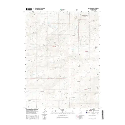
2015 Map of Miller Mountain
USGS Topo · Published 2015About this map
Lassen National Forest territory dominates this high-elevation landscape of eastern Shasta County, characterized by a dense network of volcanic buttes and alpine drainages. The area is defined by its water resources, from the Kilarc Reservoir and Blue Lake to the headwaters of Clover Cr and Old Cow Cr. Evidence of early mountain transit and settlement is found in family-named landmarks like Dan Hunt Meadows and Miller Valley, as well as several established timber and fire-lookout points including Lookout Mtn and Sugar Pine Mtn. The naming of Cascade School Rd and Backachers Way suggests the historical challenges of navigating this varied terrain. Geologic features like Stacher Butte and Cutter Butte serve as prominent landmarks for researchers tracing the development of this forest region.
Find a feature on this map
47 named features on this map. Tap any name to fly to it.
Don’t see what you’re looking for? This feature index may not catch every label — zoom into the map to look around manually.
Map Details
Editions of this 2015 Miller Mountain Map
This is the sole edition of this map. No revisions or reprints were ever made.
Other maps of this area

1886 · Lassen Peak
USGS Topo · 1:250,000

1892 · Lassen Peak
USGS Topo · 1:250,000

1894 · Lassen Peak
USGS Topo · 1:250,000

1935 · Burney
USGS Topo · 1:96,000

1939 · Burney
USGS Topo · 1:125,000

1955 · Westwood
USGS Topo · 1:250,000

1956 · Manzanita Lake
USGS Topo · 1:62,500
1956 · Whitmore
USGS Topo · 1:62,500
1956 · Montgomery Creek
USGS Topo · 1:62,500

1957 · Burney
USGS Topo · 1:62,500