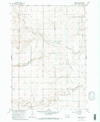
1967 Map of Miller NW
USGS Topo · Published 1969About this map
Schaefer Creek and Lost Creek wind through this prairie landscape of Hand County during the late 1960s, a period when the rural school system still defined the local community structure. The map reveals a highly organized township grid, including Howell, Carlton, Florence, Holden, Alpha, and York, which underscores the systematic settlement of the Missouri River Basin.
Find a feature on this map
13 named features on this map. Tap any name to fly to it.
Don’t see what you’re looking for? This feature index may not catch every label — zoom into the map to look around manually.
Map Details
Editions of this 1967 Miller NW Map
2 editions found
Other maps of this area

1899 · Redfield
USGS Topo · 1:125,000

1950 · Ree Heights SE
USGS Topo · 1:24,000

1951 · Polo
USGS Topo · 1:24,000

1951 · Ree Heights NE
USGS Topo · 1:24,000

1953 · Huron
USGS Topo · 1:250,000

1954 · Huron
USGS Topo · 1:250,000

1966 · Burdette
USGS Topo · 1:24,000
1966 · Rockham SW
USGS Topo · 1:24,000
1966 · Rockham SE
USGS Topo · 1:24,000

1967 · Miller
USGS Topo · 1:24,000