
1961 Map of Miller SW
USGS Topo · Published 1963About this map
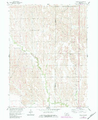
Wood River runs along the northern edge of this territory, where the border of Dawson and Buffalo counties divides a landscape defined by rolling prairie and intricate creek drainage. This 1961 survey, conducted for the Department of the Interior's Missouri River Basin development program, shows a rural Nebraska topography of deep-cut draws and narrow ridges. Settlement patterns follow the water, with farmsteads scattered between Cherry Valley in the north and the lower valley of Elm Creek to the south. Local community life is anchored by small rural institutions like School No 63 and School No 83, alongside the Fairview Cem. The presence of the Dawson Co Canal in the southwestern corner highlights the vital role of water management in sustaining agriculture throughout the Overton and Elm Creek townships.
Find a feature on this map
14 named features on this map. Tap any name to fly to it.
Don’t see what you’re looking for? This feature index may not catch every label — zoom into the map to look around manually.
Map Details
Editions of this 1961 Miller SW Map
2 editions found
Other maps of this area

1896 · Lexington
USGS Topo · 1:125,000

1896 · Kearney
USGS Topo · 1:125,000

1899 · Lexington
USGS Topo · 1:125,000

1955 · Grand Island
USGS Topo · 1:250,000

1957 · Grand Island
USGS Topo · 1:250,000

1958 · Grand Island
USGS Topo · 1:250,000

1961 · Elm Creek West
USGS Topo · 1:24,000

1961 · Amherst
USGS Topo · 1:24,000

1962 · Elm Creek East
USGS Topo · 1:24,000

1962 · Lexington SE
USGS Topo · 1:24,000