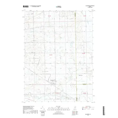
2019 Map of Millersburg
USGS Topo · Published 2019About this map
Millersburg sits at the heart of this landscape, where the agricultural plains of northern Indiana are defined by an intricate network of drainage ditches and small family-named cemeteries. The town's layout, centered on Elm St and Larimer Dr, reveals a classic Midwestern settlement pattern surrounded by fertile fields. The region’s hydrology is managed through named waterways like McAllister Ditch and Boyer Ditch, while the Elkhart River flows through the southern reaches. This modern survey also documents a recreational layer over the rural grid, prominently featuring the Miami Snowmobile Trail (Snow) as it winds through the countryside. Genealogists will find significant value in the distribution of burial grounds across the townships, including Miller Cem, Nisley Cem, and Bontrager Cem, which mark the historical footprint of early settling families in Elkhart and LaGrange Counties.
Find a feature on this map
64 named features on this map. Tap any name to fly to it.
Don’t see what you’re looking for? This feature index may not catch every label — zoom into the map to look around manually.
Map Details
Editions of this 2019 Millersburg Map
This is the sole edition of this map. No revisions or reprints were ever made.
Other maps of this area

1951 · Milford
USGS Topo · 1:24,000

1951 · Wawasee
USGS Topo · 1:24,000

1953 · Fort Wayne
USGS Topo · 1:250,000

1956 · Fort Wayne
USGS Topo · 1:250,000

1956 · Ligonier
USGS Topo · 1:24,000

1959 · Topeka
USGS Topo · 1:24,000

1959 · Millersburg
USGS Topo · 1:24,000

1959 · Goshen
USGS Topo · 1:24,000
1961 · Shipshewana
USGS Topo · 1:24,000
1961 · Lake Wawasee
USGS Topo · 1:24,000