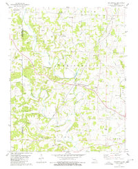
1980 Map of Millersville
USGS Topo · Published 1980About this map
Whitewater River meandering through the heart of Cape Girardeau County defines the landscape of this 1980 survey. The map documents a rural Missouri network of small settlements and family-named landmarks, most notably Millersville and Kurreville. A high density of burial sites, including the Old Caney Fork Cem and Niswonger Cem, provides significant value for genealogists tracing pioneer lineages in the region.
Find a feature on this map
56 named features on this map. Tap any name to fly to it.
Don’t see what you’re looking for? This feature index may not catch every label — zoom into the map to look around manually.
Map Details
Editions of this 1980 Millersville Map
This is the sole edition of this map. No revisions or reprints were ever made.
Other maps of this area

1918 · Altenburg
USGS Topo · 1:62,500

1922 · Cape Girardeau
USGS Topo · 1:62,500

1923 · Perryville
USGS Topo · 1:62,500

1924 · Cape Girardeau
USGS Topo · 1:62,500

1924 · Perryville
USGS Topo · 1:62,500

1925 · Altenburg
USGS Topo · 1:62,500

1933 · Marble Hill
USGS Topo · 1:62,500

1937 · Marble Hill
USGS Topo · 1:62,500

1947 · Oak Ridge
USGS Topo · 1:24,000

1947 · Altenburg
USGS Topo · 1:62,500