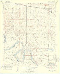
1951 Map of Millerton
USGS Topo · Published 1952About this map
The Red River defines the winding border between Oklahoma and Texas, dominated by the prominent loop of Horseshoe Bend and the nearby Cut-off. This early 1950s survey of McCurtain County reveals a rural landscape anchored by small communities and localized institutions. The St Louis San Francisco railroad runs across the northern edge, connecting the towns of Valliant and Millerton. To the south, the terrain descends toward the river lowlands, marked by Whitegrass Flats and numerous sloughs like Salt Well Slough. Local social life is evidenced by scattered country schools and houses of worship, including Mt Zion Sch, Forest Hill Sch, and Clear Creek Ch. The presence of the Clear Creek Cem and named landmarks such as Farmers Hill provide specific points of interest for those researching family history in the Wilson and Kirk districts.
Find a feature on this map
35 named features on this map. Tap any name to fly to it.
Don’t see what you’re looking for? This feature index may not catch every label — zoom into the map to look around manually.
Map Details
Editions of this 1951 Millerton Map
2 editions found
Other maps of this area

1901 · Alikchi
USGS Topo · 1:125,000

1902 · Lukfata
USGS Topo · 1:125,000

1950 · Mcalester
USGS Topo · 1:250,000

1950 · Acworth
USGS Topo · 1:24,000

1951 · Garvin
USGS Topo · 1:24,000

1951 · Acworth
USGS Topo · 1:24,000

1951 · Millerton
USGS Topo · 1:24,000

1951 · Negley
USGS Topo · 1:24,000

1951 · Kiomatia
USGS Topo · 1:24,000

1951 · Manchester
USGS Topo · 1:24,000