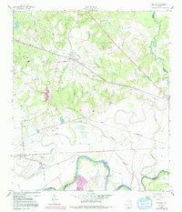
1959 Map of Millican
USGS Topo · Published 1991About this map
Millican stands as a focal point in the Brazos Valley during the late 1950s, situated between the Brazos River and the Navasota River. The landscape is defined by the convergence of these major waterways and the industrial infrastructure of the era, including numerous gas wells, an oil well, and a cotton gin near the river bend. The map documents the rural community structure through family and community landmarks such as Brooks Chapel, Millican Ch, and several burial grounds including Weaver Cem and Barker Cem. Significant topographical features like Hidalgo Falls on the Brazos indicate the natural obstacles and landmarks of the river system. Transportation history is visible in the path of the Southern Pacific railroad and remnants of an Old Railroad Grade near Dallam, tracing the evolution of movement through these fertile bottomlands.
Find a feature on this map
35 named features on this map. Tap any name to fly to it.
Don’t see what you’re looking for? This feature index may not catch every label — zoom into the map to look around manually.
Map Details
Editions of this 1959 Millican Map
4 editions found
Other maps of this area

1913 · Millican
USGS Topo · 1:31,680

1914 · Gay Hill
USGS Topo · 1:62,500

1914 · Navasota
USGS Topo · 1:62,500

1954 · Austin
USGS Topo · 1:250,000

1956 · Bryan
USGS Topo · 1:62,500

1956 · Carlos
USGS Topo · 1:62,500

1958 · Washington
USGS Topo · 1:24,000

1958 · Navasota
USGS Topo · 1:24,000

1958 · Courtney
USGS Topo · 1:24,000

1959 · Millican
USGS Topo · 1:24,000