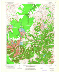
1963 Map of Millport
USGS Topo · Published 1964About this map
The Pond River forms the western boundary of this landscape, separating Hopkins and Muhlenberg counties during an era of significant industrial transformation. To the north, the small community of Millport and the nearby Stringtown sit along the Louisville and Nashville railroad line, representing the traditional settlement patterns of the region. However, the map is dominated by the sprawling footprint of the coal industry. Massive Strip Mine operations have reshaped the terrain south of Earle, leaving a distinct topographic signature that contrasts with the natural drainages of Log Creek and Isaacs Creek. Local history is preserved in landmarks such as Corley Chapel and the Salem Cem, while the town of Graham anchors the southern portion of the sheet near Graham Lake. This document captures the heavy infrastructure of the mid-century, from the Illinois Central tracks to the extensive networks of Gas Well and Oil Well sites dotting the area.
Find a feature on this map
27 named features on this map. Tap any name to fly to it.
Don’t see what you’re looking for? This feature index may not catch every label — zoom into the map to look around manually.
Map Details
Editions of this 1963 Millport Map
3 editions found
Other maps of this area

1909 · Madisonville
USGS Topo · 1:62,500

1909 · Central City
USGS Topo · 1:62,500

1911 · Drakesboro
USGS Topo · 1:48,000

1912 · Nortonville
USGS Topo · 1:62,500

1913 · Drakesboro
USGS Topo · 1:62,500

1952 · Livermore
USGS Topo · 1:24,000

1952 · Sacramento
USGS Topo · 1:24,000

1952 · Greenville
USGS Topo · 1:24,000

1952 · Hanson
USGS Topo · 1:24,000

1953 · Nortonville
USGS Topo · 1:24,000