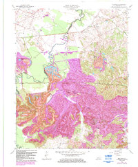
1963 Map of Millport
USGS Topo · Published 1983About this map
The Pond River serves as a winding boundary between Hopkins and Muhlenberg counties, defining a landscape shaped by coal extraction and a network of small western Kentucky settlements. Large Strip Mine operations dominate much of the terrain, particularly south of Earle and near Graham, where the topography reflects the extensive surface mining activity of the mid-20th century. Transportation for this industrial and agricultural region relied on the Seaboard and Illinois Central Gulf rail lines, which cut through the hills and river bottoms.
Find a feature on this map
26 named features on this map. Tap any name to fly to it.
Don’t see what you’re looking for? This feature index may not catch every label — zoom into the map to look around manually.
Map Details
Editions of this 1963 Millport Map
3 editions found
Other maps of this area

1909 · Madisonville
USGS Topo · 1:62,500

1909 · Central City
USGS Topo · 1:62,500

1911 · Drakesboro
USGS Topo · 1:48,000

1912 · Nortonville
USGS Topo · 1:62,500

1913 · Drakesboro
USGS Topo · 1:62,500

1952 · Livermore
USGS Topo · 1:24,000

1952 · Sacramento
USGS Topo · 1:24,000

1952 · Greenville
USGS Topo · 1:24,000

1952 · Hanson
USGS Topo · 1:24,000

1953 · Nortonville
USGS Topo · 1:24,000