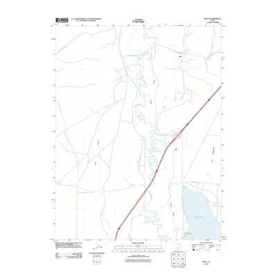
2010 Map of Mills
USGS Topo · Published 2010About this map
The Sevier River snakes through Mills Valley and Little Valley in this 2010 survey of central Utah. The settlement of Mills serves as a focal point in a landscape defined by dramatic hydrological and geological features. In the southern portion of the quadrangle, the Sevier Bridge Reservoir provides a significant water body, flanked by the Yuba Campground and the prominent incline of Badeau Ridge. Local topography is further distinguished by named landmarks such as Red Point and the curiously named The Washboard. This map provides a detailed look at the area's rural road network, including Leamington Pass Rd and Mecham Rd, which connect the valley floors to the surrounding hills. Water sources like Chase Springs, Blue Springs, and Molten Spring underscore the importance of natural springs to the region's geography and history.
Find a feature on this map
17 named features on this map. Tap any name to fly to it.
Don’t see what you’re looking for? This feature index may not catch every label — zoom into the map to look around manually.
Map Details
Editions of this 2010 Mills Map
This is the sole edition of this map. No revisions or reprints were ever made.
Other maps of this area

1885 · Manti
USGS Topo · 1:250,000

1885 · Sevier Desert
USGS Topo · 1:250,000

1895 · Manti
USGS Topo · 1:250,000

1951 · Nephi
USGS Topo · 1:62,500

1952 · Scipio North
USGS Topo · 1:62,500

1953 · Delta
USGS Topo · 1:250,000

1956 · Price
USGS Topo · 1:250,000

1958 · Delta
USGS Topo · 1:250,000

1960 · Price
USGS Topo · 1:250,000

1962 · Price
USGS Topo · 1:250,000