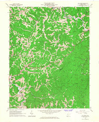
1965 Map of Millstone
USGS Topo · Published 1967About this map
Oil wells and gas wells pepper the ridges and hollows of central Calhoun County during the mid-1960s, documenting the extensive energy extraction network that defined this part of the West Virginia hills. The landscape is marked by small settlements and crossroads such as Millstone, Sand Ridge, and Mt Zion, connected by W Va 16 and numerous secondary roads that follow the winding drainage of Millstone Creek and Crummis Creek. Local life centers around rural institutions like Alberta Chapel, Sycamore Church, and the Apple Grove Sch, while a Drive-in Theater near the northern boundary provides a rare glimpse into the mid-century social recreation of the area. Notable terrain features like Sassafras Ridge separate the various runs, including Slabcamp Run and Mudlick Run, illustrating the deeply dissected topography of the region as it transitioned from agricultural homesteads to industrial resource extraction.
Find a feature on this map
61 named features on this map. Tap any name to fly to it.
Don’t see what you’re looking for? This feature index may not catch every label — zoom into the map to look around manually.
Map Details
Editions of this 1965 Millstone Map
This is the sole edition of this map. No revisions or reprints were ever made.
Other maps of this area

1893 · Sutton
USGS Topo · 1:125,000

1906 · Glenville
USGS Topo · 1:62,500

1906 · Otter
USGS Topo · 1:62,500

1907 · Otter
USGS Topo · 1:62,500

1907 · Arnoldsburg
USGS Topo · 1:62,500

1908 · Gassaway
USGS Topo · 1:48,000

1910 · Gassaway
USGS Topo · 1:62,500

1925 · Glenville
USGS Topo · 1:62,500

1925 · Arnoldsburg
USGS Topo · 1:62,500

1927 · Arnoldsburg
USGS Topo · 1:62,500