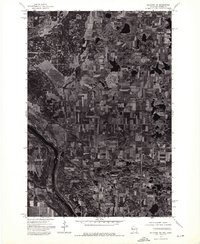
1974 Map of Milltown SW
USGS Topo · Published 1976About this map
The St Croix River carves a deep path through the southwestern corner of this 1974 orthophotoquad, defining the border between Wisconsin and Minnesota. This specialized map format uses rectified aerial imagery to show the mid-1970s landscape in photographic detail, revealing a dense patchwork of agricultural fields and woodlots that characterize this part of Polk County. The small settlement of Cushing is visible as a focal point for the surrounding rural road network. Numerous glacial kettle lakes and wetlands pockmark the terrain, illustrating the region's post-glacial topography before modern development altered these drainage patterns. Local history researchers can use this visual record to identify exact farmstead locations and the extent of forest cover during this period.
Find a feature on this map
2 named features on this map. Tap any name to fly to it.
Don’t see what you’re looking for? This feature index may not catch every label — zoom into the map to look around manually.
Map Details
Editions of this 1974 Milltown SW Map
This is the sole edition of this map. No revisions or reprints were ever made.
Other maps of this area

1900 · St Croix Dalles
USGS Topo · 1:62,500

1901 · St Croix Dalles
USGS Topo · 1:62,500

1950 · Rush City
USGS Topo · 1:48,000

1951 · Milltown
USGS Topo · 1:48,000

1953 · Stillwater
USGS Topo · 1:250,000

1955 · St. Croix Dalles
USGS Topo · 1:62,500

1955 · Rush City
USGS Topo · 1:62,500

1955 · Milltown
USGS Topo · 1:62,500

1955 · Forest Lake
USGS Topo · 1:62,500

1955 · Stillwater
USGS Topo · 1:250,000