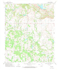
1969 Map of Milo
USGS Topo · Published 1971About this map
The Arbuckle Mountains dominate the northern landscape of this Carter County region, where the terrain drops away into a complex network of drainages including Caddo Creek and Hickory Creek. In the late 1960s, the rural community of Milo served as a central point for local families, supported by the Milo Cem and nearby St Paul Ch. Further east, the settlement of Woodford sits near the headwaters of Salt Creek, while Newport marks the southern extent of the survey area.
Find a feature on this map
30 named features on this map. Tap any name to fly to it.
Don’t see what you’re looking for? This feature index may not catch every label — zoom into the map to look around manually.
Map Details
Editions of this 1969 Milo Map
This is the sole edition of this map. No revisions or reprints were ever made.
Other maps of this area

1901 · Ardmore
USGS Topo · 1:125,000

1918 · Ardmore
USGS Topo · 1:125,000

1957 · Ardmore
USGS Topo · 1:250,000

1963 · Ardmore
USGS Topo · 1:250,000

1964 · Ardmore West
USGS Topo · 1:24,000

1964 · Springer
USGS Topo · 1:24,000

1964 · Turner Falls
USGS Topo · 1:24,000

1968 · Fox NE
USGS Topo · 1:24,000

1969 · Healdton
USGS Topo · 1:24,000

1969 · Lone Grove
USGS Topo · 1:24,000