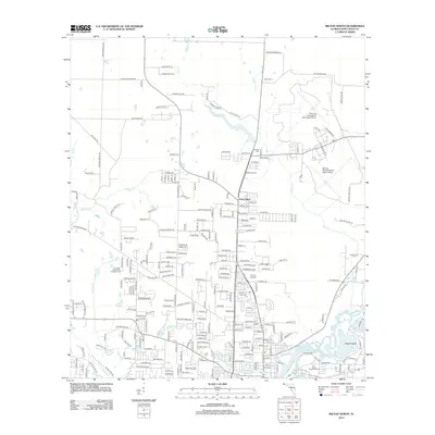
2012 Map of Milton North
USGS Topo · Published 2012About this map
The Whiting Field Naval Air Station North and its southern counterpart dominate the northeastern corner of this Florida landscape, illustrating the significant military footprint in Santa Rosa County. The surrounding residential growth is evident in settlements like Point Baker and established neighborhoods such as Whispering Pnes and Bright Mdws. The geography is defined by the winding course of the Blackwater River, which feeds into Marquis Basin and Wright Basin, creating a distinct network of waterways including Pond Cr and Clear Cr. Local history is anchored by sites like Allen Cem and Mitchell Cem, while the Evangel Fellowship Campground and Locklin Lake highlight the community's recreational and spiritual spaces. The transportation network, including Mayburn Bridge Rd and Willard Norris Rd, connects these rural and suburban pockets to the commercial activity at Six Flags Shoppers Mart.
Find a feature on this map
244 named features on this map. Tap any name to fly to it.
Don’t see what you’re looking for? This feature index may not catch every label — zoom into the map to look around manually.
Map Details
Editions of this 2012 Milton North Map
This is the sole edition of this map. No revisions or reprints were ever made.
Other maps of this area

1920 · Milton
USGS Topo · 1:62,500

1934 · Harold
USGS Topo · 1:62,500

1937 · Harold
USGS Topo · 1:62,500

1938 · Harold
USGS Topo · 1:62,500

1941 · Milton
USGS Topo · 1:62,500

1943 · Milton
USGS Topo · 1:62,500

1943 · Jay
USGS Topo · 1:62,500
1944 · Floridatown
USGS Topo · 1:25,000

1948 · Munson
USGS Topo · 1:62,500

1950 · Munson
USGS Topo · 1:62,500