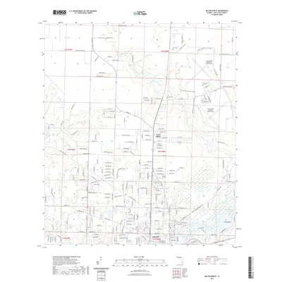
2021 Map of Milton North
USGS Topo · Published 2021About this map
Milton and the northern residential expansions near Point Baker anchor the southern portion of this landscape, where the Blackwater River and Quinn Bayou define the local topography. This 2021 survey illustrates the modern layout of military and civilian life in Santa Rosa County, centered around the sprawling complex of Whiting Field Naval Air Station North and its southern counterpart. For those researching local heritage, the map identifies several significant burial sites, including the Milton Historic Cem - Berryhill, as well as the Mitchell Cem and Allen Cem further north. The drainage patterns of Clear Creek, Pond Creek, and Reader Creek cut through the terrain, leading toward the wetland environments of Wright Basin and Locklin Lake. The map also details a dense network of residential streets and rural corridors like Horace Lunsford Rd and Jesse Allen Rd.
Find a feature on this map
229 named features on this map. Tap any name to fly to it.
Don’t see what you’re looking for? This feature index may not catch every label — zoom into the map to look around manually.
Map Details
Editions of this 2021 Milton North Map
This is the sole edition of this map. No revisions or reprints were ever made.
Other maps of this area

1920 · Milton
USGS Topo · 1:62,500

1934 · Harold
USGS Topo · 1:62,500

1937 · Harold
USGS Topo · 1:62,500

1938 · Harold
USGS Topo · 1:62,500

1941 · Milton
USGS Topo · 1:62,500

1943 · Milton
USGS Topo · 1:62,500

1943 · Jay
USGS Topo · 1:62,500
1944 · Floridatown
USGS Topo · 1:25,000

1948 · Munson
USGS Topo · 1:62,500

1950 · Munson
USGS Topo · 1:62,500