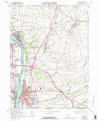
1965 Map of Milton
USGS Topo · Published 1991About this map
The West Branch Susquehanna River acts as the central spine for this mid-1960s study, dividing the industrial and residential core of Milton from the western banks of Union Co. The urban landscape of Milton is densely detailed, showing the Penn Central rail lines and various civic institutions such as the Milton Cemetery and Harmony Cemetery. To the north, the corridor following the river includes the established boroughs of Watsontown and Dewart, while the eastern interior transitions into the agricultural reaches of Turbot and Lewis townships.
Find a feature on this map
63 named features on this map. Tap any name to fly to it.
Don’t see what you’re looking for? This feature index may not catch every label — zoom into the map to look around manually.
Map Details
Editions of this 1965 Milton Map
4 editions found
Other maps of this area

1892 · Shamokin
USGS Topo · 1:62,500

1893 · Sunbury
USGS Topo · 1:62,500

1893 · Shamokin
USGS Topo · 1:62,500

1924 · Milton
USGS Topo · 1:62,500

1935 · Hughesville
USGS Topo · 1:62,500

1943 · Shamokin
USGS Topo · 1:62,500

1943 · Sunbury
USGS Topo · 1:62,500

1950 · Harrisburg
USGS Topo · 1:250,000

1952 · Shamokin
USGS Topo · 1:62,500

1953 · Hughesville
USGS Topo · 1:62,500