
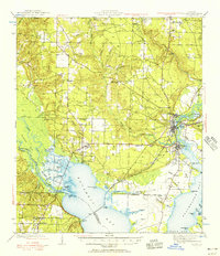
1941 Map of Milton
USGS Topo · Published 1956About this map
Milton and Bagdad serve as the primary hubs of development along the Blackwater River, where an intricate network of bayous and basins meets the head of Escambia Bay. Surveyed in the early 1940s, this landscape is defined by the convergence of heavy rail transport and tidewater geography, with the Louisville and Nashville RR and the Nashville and Northwestern RR cutting through the coastal lowlands. Away from the riverfronts, the map documents a rural interior populated by family-named landmarks and early community centers like Wallace, Pace, and Floridatown. Genealogy researchers will find several localized burial sites, including Allen Cem and Strickland Cem, along with the Robinson Sch and Union Valley Ch. The terrain transitions from the marshy reaches of Brosnaham Island to the higher ground of Pea Ridge, illustrating the historical settlement patterns of Santa Rosa and Escambia counties.
Find a feature on this map
78 named features on this map. Tap any name to fly to it.
Don’t see what you’re looking for? This feature index may not catch every label — zoom into the map to look around manually.
Map Details
Editions of this 1941 Milton Map
2 editions found
Other maps of this area

1920 · Milton
USGS Topo · 1:62,500

1921 · Holley
USGS Topo · 1:62,500

1921 · Pensacola
USGS Topo · 1:62,500

1921 · Fort Barrancas
USGS Topo · 1:62,500

1921 · Muscogee
USGS Topo · 1:62,500

1934 · Harold
USGS Topo · 1:62,500

1936 · Holley
USGS Topo · 1:48,000

1937 · Harold
USGS Topo · 1:62,500

1938 · Holley
USGS Topo · 1:62,500

1938 · Harold
USGS Topo · 1:62,500