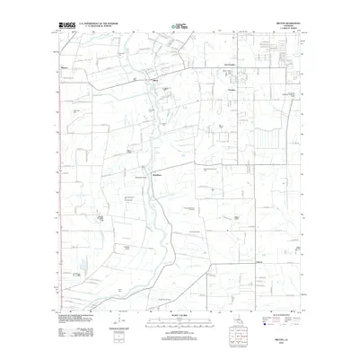
2012 Map of Milton
USGS Topo · Published 2012About this map
The Vermilion River snakes through this Lafayette Parish landscape, serving as a central artery for the surrounding Acadiana settlements of Milton and Maurice. The map reveals a complex water management system necessary for the low-lying terrain, characterized by a network of drainage features such as Steiner Canal, Prejean Canal, and Leblanc Ditch. This era shows a significant industrial presence tied to the region's mineral wealth, with extensive operations at the West Parperdue Oil and Gas Field and the Grosse Isle Gas Field. Genealogical interest is anchored by several family-named burial sites, including Broussard Cem and Picard Cem, while local infrastructure is marked by landmarks like the Woodlawn Bridge and Greene Air Park. The landscape is a mix of traditional bayous like Bayou Parc Perdu and modern utility sites like the Youngsville Wastewater Treatment Facility, reflecting the ongoing development of the area south of Lafayette.
Find a feature on this map
155 named features on this map. Tap any name to fly to it.
Don’t see what you’re looking for? This feature index may not catch every label — zoom into the map to look around manually.
Map Details
Editions of this 2012 Milton Map
This is the sole edition of this map. No revisions or reprints were ever made.
Other maps of this area

1932 · Abbeville NE
USGS Topo · 1:31,680

1932 · Abbeville NW
USGS Topo · 1:31,680

1934 · Duson
USGS Topo · 1:31,680

1937 · Derouen
USGS Topo · 1:62,500

1939 · St. Martinsville
USGS Topo · 1:62,500

1945 · New Orleans
USGS Topo · 1:250,000

1946 · Milton
USGS Topo · 1:31,680

1946 · Leroy
USGS Topo · 1:31,680

1946 · Lafayette
USGS Topo · 1:31,680

1952 · Lake Charles
USGS Topo · 1:250,000