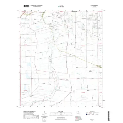
2018 Map of Milton
USGS Topo · Published 2018About this map
The Vermilion River carves a winding path through this Acadiana landscape, separating the residential growth of Milton and Youngsville from the agricultural expanses to the west. This 2018 survey captures a region defined by its coulees and drainage networks, including Anselm Goulee, LeBlanc Ditch, and Long Pointe Coulee, which traditionally dictated land use and settlement patterns. Genealogy researchers will find several family-named burial sites across the parishes, such as Broussard Cem, Picard Cem, Gallet Cem, and Bodoin Cem. Significant local landmarks are also documented, ranging from the Woodlawn Bridge crossing the river to the Greene Air Park located south of Milton. The map provides a clear view of the parish line between Lafayette and Vermilion Parishes, showing how contemporary road networks like Maurice Ave and Milton Rd have integrated these historically distinct communities.
Find a feature on this map
148 named features on this map. Tap any name to fly to it.
Don’t see what you’re looking for? This feature index may not catch every label — zoom into the map to look around manually.
Map Details
Editions of this 2018 Milton Map
This is the sole edition of this map. No revisions or reprints were ever made.
Other maps of this area

1932 · Abbeville NE
USGS Topo · 1:31,680

1932 · Abbeville NW
USGS Topo · 1:31,680

1934 · Duson
USGS Topo · 1:31,680

1937 · Derouen
USGS Topo · 1:62,500

1939 · St. Martinsville
USGS Topo · 1:62,500

1945 · New Orleans
USGS Topo · 1:250,000

1946 · Milton
USGS Topo · 1:31,680

1946 · Leroy
USGS Topo · 1:31,680

1946 · Lafayette
USGS Topo · 1:31,680

1952 · Lake Charles
USGS Topo · 1:250,000