
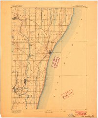
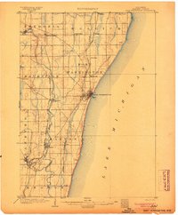
1901 Map of Milwaukee
USGS Topo · Published 1901About this map
Milwaukee at the beginning of the twentieth century is a dense industrial and maritime hub concentrated around Milwaukee Bay and the mouth of the Milwaukee River. The city's grid is already well-defined, transitioning northward into a landscape of smaller settlements and agricultural townships like Granville and Mequon. Transportation defines the geography, with the Chicago and Northwestern R. R. and the Milwaukee and St. Paul R. R. radiating from the urban core. To the north, the Lake Shore Line follows the bluffs overlooking Lake Michigan. Notable pockets of development appear at Whitefish Bay and Fox Point, while inland, the river supports small communities like Thiensville and Silver Spring. The map documents a period before the sprawling suburbanization of the late 20th century, capturing individual depots like Dillman Sta. and localized centers such as Berthelet and Lindwurm that were later absorbed into the growing metropolis.
Find a feature on this map
30 named features on this map. Tap any name to fly to it.
Don’t see what you’re looking for? This feature index may not catch every label — zoom into the map to look around manually.
Map Details
Editions of this 1901 Milwaukee Map
This is the sole edition of this map. No revisions or reprints were ever made.
Other maps of this area

1891 · Bayview
USGS Topo · 1:62,500

1891 · Muskego
USGS Topo · 1:62,500

1892 · Milwaukee
USGS Topo · 1:62,500

1892 · Waukesha
USGS Topo · 1:62,500
1892 · Port Washington
USGS Topo · 1:62,500

1901 · Waukesha
USGS Topo · 1:62,500

1901 · Bayview
USGS Topo · 1:62,500

1901 · Muskego
USGS Topo · 1:62,500

1904 · West Bend
USGS Topo · 1:62,500
1904 · Port Washington
USGS Topo · 1:62,500