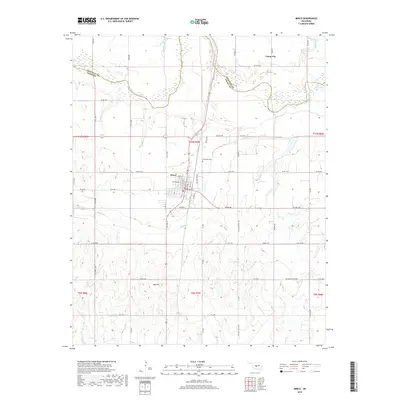
2018 Map of Minco
USGS Topo · Published 2018About this map
The Canadian River meanders across the northern portion of this landscape, marking the natural boundary between Canadian and Grady counties. Near the center of the sheet, the town of Minco serves as a local hub, defined by its traditional street grid including Main St and North St. The surrounding terrain transitions from the river bottomlands to the elevated height of Red Hill in the south, where the drainage networks of Buggy Creek and Salt Creek begin to carve through the prairie. To the north, the smaller settlement of Union City sits near the upper reaches of Beaver Creek. For local historians and genealogists, the map preserves the exact location of Evergreen Cemetery and a network of section-line roads like SW Gin Rd that reflect the agricultural heritage of this Oklahoma territory.
Find a feature on this map
65 named features on this map. Tap any name to fly to it.
Don’t see what you’re looking for? This feature index may not catch every label — zoom into the map to look around manually.
Map Details
Editions of this 2018 Minco Map
This is the sole edition of this map. No revisions or reprints were ever made.
Other maps of this area

1893 · Buggy Creek
USGS Topo · 1:62,500

1893 · Minco
USGS Topo · 1:62,500

1904 · Chickasha
USGS Topo · 1:125,000

1945 · Anadarko
USGS Topo · 1:62,500

1954 · Oklahoma City
USGS Topo · 1:250,000

1955 · Clinton
USGS Topo · 1:250,000

1957 · Clinton
USGS Topo · 1:250,000

1957 · Oklahoma City
USGS Topo · 1:250,000

1963 · Oklahoma City
USGS Topo · 1:250,000
1966 · Minco NE
USGS Topo · 1:24,000