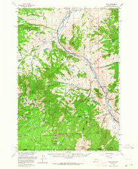
1955 Map of Miner
USGS Topo · Published 1964About this map
Yellowstone River carving through the heart of the northern Montana high country defines this 1955 survey. The Northern Pacific railroad tracks follow the river's path through the narrow Yankee Jim Canyon, a corridor of historical transit that links small mountain settlements. At the southern edge of the map, the boundary for Yellowstone National Park reveals a landscape of high peaks and alpine lakes, including Electric Peak and Sportsman Lake.
Find a feature on this map
68 named features on this map. Tap any name to fly to it.
Don’t see what you’re looking for? This feature index may not catch every label — zoom into the map to look around manually.
Map Details
Editions of this 1955 Miner Map
4 editions found
Other maps of this area

1885 · Gallatin
USGS Topo · 1:125,000

1885 · Gallatin
USGS Topo · 1:125,000

1888 · Three Forks
USGS Topo · 1:250,000

1891 · Livingston
USGS Topo · 1:250,000

1893 · Livingston
USGS Topo · 1:250,000

1894 · Three Forks
USGS Topo · 1:250,000

1895 · Three Forks
USGS Topo · 1:250,000

1901 · Gallatin
USGS Topo · 1:125,000

1908 · Gallatin
USGS Topo · 1:125,000

1911 · Gallatin
USGS Topo · 1:125,000