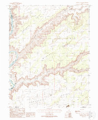
1988 Map of Mineral Canyon
USGS Topo · Published 1988About this map
The Green River carves a serpentine path through this 1988 survey, defining the intersection of Grand, Emery, and San Juan counties. The landscape is dominated by massive elevated plateaus, including Deadman Point, Mineral Point, and Horsethief Point, which loom over the deep incisions of Mineral Canyon and Roaring Hell Canyon. Along the river banks, low-lying areas such as Mineral Bottom, Tidwell Bottom, and Spring Canyon Bottom provide rare points of access to the water's edge.
Find a feature on this map
23 named features on this map. Tap any name to fly to it.
Don’t see what you’re looking for? This feature index may not catch every label — zoom into the map to look around manually.
Map Details
Editions of this 1988 Mineral Canyon Map
2 editions found
Other maps of this area

1885 · San Rafael
USGS Topo · 1:250,000

1885 · La Sal
USGS Topo · 1:250,000

1951 · The Knoll
USGS Topo · 1:62,500

1951 · Upheaval Dome
USGS Topo · 1:62,500

1952 · Tidwell 4 SE
USGS Topo · 1:24,000

1952 · Moab 3 NE
USGS Topo · 1:24,000

1952 · Carlisle 2 NW
USGS Topo · 1:24,000

1952 · Moab 3 SE
USGS Topo · 1:24,000

1952 · Carlisle 2 NE
USGS Topo · 1:24,000

1952 · Tidwell 4 NE
USGS Topo · 1:24,000