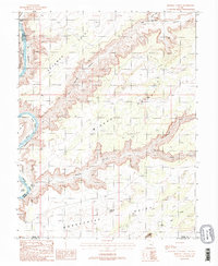
1988 Map of Mineral Canyon
USGS Topo · Published 1988About this map
Green River carves a winding path through this corner of Grand and Emery Counties, creating the dramatic loop of Bowknot Bend and the steep walls of Labyrinth Canyon. The landscape is dominated by high plateaus including Deadman Point, Mineral Point, and Horsethief Point, which loom over the river bottoms and the deep incision of Hell Roaring Canyon. Small-scale resource extraction is evident through scattered prospects, a gravel pit, and a sandpit, while the lower portion of the map enters the northern reaches of Canyonlands National Park. Evidence of 1980s-era land use is visible in the network of 4wd tracks that provide access to remote areas like Mineral Bottom and Tidwell Bottom, highlighting the transition of this area from a mining and ranching frontier to a recreational and protected landscape.
Find a feature on this map
30 named features on this map. Tap any name to fly to it.
Don’t see what you’re looking for? This feature index may not catch every label — zoom into the map to look around manually.
Map Details
Editions of this 1988 Mineral Canyon Map
2 editions found
Other maps of this area

1885 · San Rafael
USGS Topo · 1:250,000

1885 · La Sal
USGS Topo · 1:250,000

1951 · The Knoll
USGS Topo · 1:62,500

1951 · Upheaval Dome
USGS Topo · 1:62,500

1952 · Tidwell 4 SE
USGS Topo · 1:24,000

1952 · Moab 3 NE
USGS Topo · 1:24,000

1952 · Carlisle 2 NW
USGS Topo · 1:24,000

1952 · Moab 3 SE
USGS Topo · 1:24,000

1952 · Carlisle 2 NE
USGS Topo · 1:24,000

1952 · Tidwell 4 NE
USGS Topo · 1:24,000