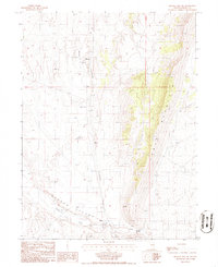
1986 Map of Mineral Hill SW
USGS Topo · Published 1986About this map
Garden Valley serves as the focal point for this 1986 survey of Eureka County, where the high desert floor meets the eastern slope of Table Mountain. The map details a landscape transition from agricultural ranching to high-altitude terrain, centered around the small settlements of Alpha and Henderson. A significant interpretive detail is the presence of the Old Railroad Grade, which runs north-south through the valley, marking the path of a former narrow-gauge line that once connected the mining districts of central Nevada to the transcontinental network. Further north, the settlement of Shannon and an adjacent Landing Strip illustrate the area's continued reliance on remote transport links. Ranching life is grounded by Alpha Ranch and the seasonal waters of Henderson Creek, while the presence of Chimney Springs and various wells underscore the vital importance of water management in this arid basin.
Find a feature on this map
17 named features on this map. Tap any name to fly to it.
Don’t see what you’re looking for? This feature index may not catch every label — zoom into the map to look around manually.
Map Details
Editions of this 1986 Mineral Hill SW Map
This is the sole edition of this map. No revisions or reprints were ever made.
Other maps of this area

1926 · Roberts Mountains
USGS Topo · 1:250,000

1929 · Roberts Mountains
USGS Topo · 1:250,000

1937 · Mineral Hill
USGS Topo · 1:48,000

1943 · Mineral Hill
USGS Topo · 1:62,500

1949 · Garden Valley
USGS Topo · 1:62,500

1949 · Roberts Creek Mtn
USGS Topo · 1:62,500

1951 · Roberts Creek Mtn
USGS Topo · 1:62,500

1951 · Garden Valley
USGS Topo · 1:62,500

1955 · Millett
USGS Topo · 1:250,000

1955 · Winnemucca
USGS Topo · 1:250,000