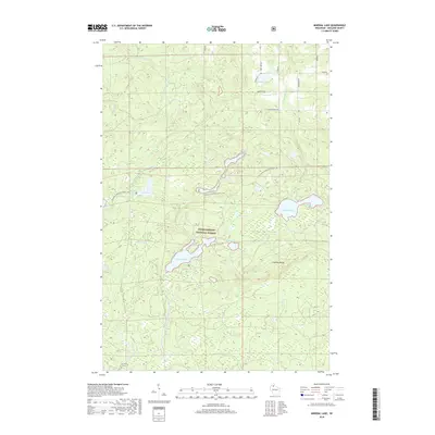
2018 Map of Mineral Lake
USGS Topo · Published 2018About this map
The Chequamegon National Forest encompasses this section of Northern Wisconsin, dominated by a dense network of glacial lakes and the rising elevations of the Gogebic Range. The landscape is defined by its complex hydrography, where the Brunsweiler River and smaller tributaries like Waboo Cr and Camp Six Cr weave through the timberland. Large bodies of water such as Mineral Lake and English Lake are central features, alongside smaller names like Lake Three, Gilbert Lake, and John Frank Lake.
Find a feature on this map
31 named features on this map. Tap any name to fly to it.
Don’t see what you’re looking for? This feature index may not catch every label — zoom into the map to look around manually.
Map Details
Editions of this 2018 Mineral Lake Map
This is the sole edition of this map. No revisions or reprints were ever made.
Other maps of this area

1942 · Glidden
USGS Topo · 1:48,000

1942 · Clam Lake
USGS Topo · 1:48,000

1942 · Mellen
USGS Topo · 1:48,000

1942 · Marengo
USGS Topo · 1:48,000

1945 · Marengo
USGS Topo · 1:48,000

1945 · Clam Lake
USGS Topo · 1:48,000

1945 · Glidden
USGS Topo · 1:48,000

1945 · Mellen
USGS Topo · 1:48,000

1953 · Ashland
USGS Topo · 1:250,000
1956 · Mellen
USGS Topo · 1:24,000