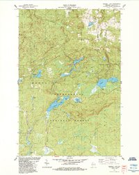
1984 Map of Mineral Lake
USGS Topo · Published 1984About this map
Mineral Lake and English Lake anchor this 1984 survey of the high woodlands within the Chequamegon National Forest. The landscape is defined by the sharp topography of the Gogebic Range, where the Brunsweiler River and numerous tributaries like Camp Six Creek and McCarthy Creek carve through the timberland. While the area is largely undeveloped, the map reveals a network of recreational and access points, including a campground on the southern shore of Mineral Lake and a picnic area at Potter Lake.
Find a feature on this map
31 named features on this map. Tap any name to fly to it.
Don’t see what you’re looking for? This feature index may not catch every label — zoom into the map to look around manually.
Map Details
Editions of this 1984 Mineral Lake Map
This is the sole edition of this map. No revisions or reprints were ever made.
Other maps of this area

1942 · Glidden
USGS Topo · 1:48,000

1942 · Clam Lake
USGS Topo · 1:48,000

1942 · Mellen
USGS Topo · 1:48,000

1942 · Marengo
USGS Topo · 1:48,000

1945 · Marengo
USGS Topo · 1:48,000

1945 · Clam Lake
USGS Topo · 1:48,000

1945 · Glidden
USGS Topo · 1:48,000

1945 · Mellen
USGS Topo · 1:48,000

1953 · Ashland
USGS Topo · 1:250,000
1956 · Mellen
USGS Topo · 1:24,000