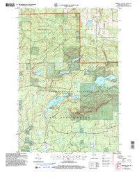
2005 Map of Mineral Lake
USGS Topo · Published 2006About this map
The Gogebic Range dominates the southern landscape of this northern Wisconsin wilderness, captured during a period of extensive forest management and recreation development. Much of the area is contained within the Chequamegon-Nicolet National Forest, including the protected Brunsweiler Semi-Primitive Non-Motorized Area along the Brunsweiler River. This 2005 revision reflects a landscape dedicated to conservation and backcountry travel, featuring a segment of the North Country National Scenic Trail winding through the timber.
Find a feature on this map
28 named features on this map. Tap any name to fly to it.
Don’t see what you’re looking for? This feature index may not catch every label — zoom into the map to look around manually.
Map Details
Editions of this 2005 Mineral Lake Map
This is the sole edition of this map. No revisions or reprints were ever made.
Other maps of this area

1942 · Glidden
USGS Topo · 1:48,000

1942 · Clam Lake
USGS Topo · 1:48,000

1942 · Mellen
USGS Topo · 1:48,000

1942 · Marengo
USGS Topo · 1:48,000

1945 · Marengo
USGS Topo · 1:48,000

1945 · Clam Lake
USGS Topo · 1:48,000

1945 · Glidden
USGS Topo · 1:48,000

1945 · Mellen
USGS Topo · 1:48,000

1953 · Ashland
USGS Topo · 1:250,000
1956 · Mellen
USGS Topo · 1:24,000