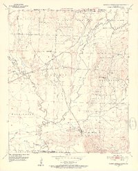
1951 Map of Mineral Springs South
USGS Topo · Published 1952About this map
Saline Landing and the winding course of the Saline River define this corner of Southwest Arkansas at the midpoint of the twentieth century. The landscape is marked by the industrial infrastructure of the Graysonia Nashville and Ashdown railroad, which services the small settlements of Mineral Springs, Schaal, and the company town of Okay, where a Quarry is located. The area is dense with community landmarks that provide significant value for genealogists, including the County Training School near Tollette, and several rural houses of worship such as Blackland Ch and Bright Star Ch. To the south, Saratoga sits near the county line, while the northern terrain transitions into the Buck Range. Extensive drainage networks like Blue Bayou and Dillard Creek carve through the various townships, illustrating the transition from upland ridges to the river bottomlands.
Find a feature on this map
35 named features on this map. Tap any name to fly to it.
Don’t see what you’re looking for? This feature index may not catch every label — zoom into the map to look around manually.
Map Details
Editions of this 1951 Mineral Springs South Map
4 editions found
Other maps of this area

1950 · Ashdown East
USGS Topo · 1:24,000

1950 · Red Bluff
USGS Topo · 1:24,000

1950 · Ben Lomond
USGS Topo · 1:24,000

1951 · Ben Lomond
USGS Topo · 1:24,000

1951 · Red Bluff
USGS Topo · 1:24,000

1951 · Ashdown East
USGS Topo · 1:24,000

1951 · Mineral Springs South
USGS Topo · 1:24,000

1951 · Columbus
USGS Topo · 1:24,000

1951 · Mineral Springs North
USGS Topo · 1:24,000

1951 · Nashville
USGS Topo · 1:24,000