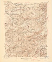
1941 Map of Mineral
USGS Topo · Published 1941About this map
Lassen Volcanic National Park dominates the northeast corner of this territory, where topographic relief climbs toward the prominent Lassen Peak and Brokeoff Mtn. South of the park boundary, the landscape within Lassen National Forest is defined by a dense network of family-named ranch sites and remote mountain settlements like Lyonsville and Mineral. This era reveals the industrial imprint of timber and hydroelectric power, evidenced by the Forward Mill, the Volta Power House, and the Inskip Power House along the canyons of North Fork Battle Creek. Many of these locations, including the Ward Goat Camp and various homesteads such as the Facht Homestead, offer a specific record of early 20th-century land use and habitation in the high country before the consolidation of modern forest management.
Find a feature on this map
151 named features on this map. Tap any name to fly to it.
Don’t see what you’re looking for? This feature index may not catch every label — zoom into the map to look around manually.
Map Details
Editions of this 1941 Mineral Map
3 editions found

Other maps of this area

1886 · Lassen Peak
USGS Topo · 1:250,000

1888 · Bidwell Bar
USGS Topo · 1:125,000

1890 · Red Bluff
USGS Topo · 1:250,000

1891 · Bidwell Bar
USGS Topo · 1:125,000

1891 · Chico
USGS Topo · 1:125,000

1892 · Lassen Peak
USGS Topo · 1:250,000

1893 · Chico
USGS Topo · 1:125,000

1893 · Bidwell Bar
USGS Topo · 1:125,000

1894 · Lassen Peak
USGS Topo · 1:250,000

1894 · Red Bluff
USGS Topo · 1:250,000