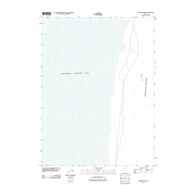
2011 Map of Miners Basin
USGS Topo · Published 2011About this map
Newfoundland Mountains rise sharply out of the salt flats in this 2011 survey of western Utah. The landscape is dominated by the massive Newfoundland Evaporation Basin, a stark hydrologic feature that reflects the industrial and environmental management of the Great Salt Lake region. Along the eastern edge of the range, Miners Basin provides a namesake landmark for this stretch of desert. This area is defined by its isolation and the dramatic shift from the flat, engineered basins to the elevated terrain of the inland mountain range, showing the intersection of natural geography and mineral extraction history in Box Elder County.
Find a feature on this map
3 named features on this map. Tap any name to fly to it.
Don’t see what you’re looking for? This feature index may not catch every label — zoom into the map to look around manually.
Map Details
Editions of this 2011 Miners Basin Map
This is the sole edition of this map. No revisions or reprints were ever made.
Other maps of this area

1954 · Brigham City
USGS Topo · 1:250,000

1958 · Brigham City
USGS Topo · 1:250,000

1962 · Brigham City
USGS Topo · 1:250,000

1983 · Desert Peak
USGS Topo · 1:24,000

1983 · Lemay
USGS Topo · 1:24,000

1983 · Bovine SE
USGS Topo · 1:24,000
1983 · Big Pass
USGS Topo · 1:24,000

1983 · Groome
USGS Topo · 1:24,000

1983 · Lucin 4 NE
USGS Topo · 1:24,000
1983 · Keller Well
USGS Topo · 1:24,000