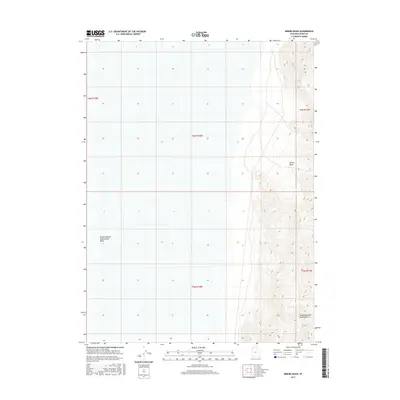
2017 Map of Miners Basin
USGS Topo · Published 2017About this map
The Newfoundland Mountains rise sharply out of the surrounding salt flats in this remote section of Box Elder County. This 2017 survey captures the stark transition between the high desert peaks and the expansive Newfoundland Evaporation Basin to the west. The topography is dominated by the steep eastern slopes of the range, including the namesake Miners Basin, a topographic depression that suggests a history of mineral exploration in these isolated heights. The map provides a clear look at the Public Land Survey System grid, including Township 6 North and Ranges 13 through 15 West, illustrating how the vast, uninhabited terrain is segmented for administrative and geological study in the modern era.
Find a feature on this map
8 named features on this map. Tap any name to fly to it.
Don’t see what you’re looking for? This feature index may not catch every label — zoom into the map to look around manually.
Map Details
Editions of this 2017 Miners Basin Map
This is the sole edition of this map. No revisions or reprints were ever made.
Other maps of this area

1954 · Brigham City
USGS Topo · 1:250,000

1958 · Brigham City
USGS Topo · 1:250,000

1962 · Brigham City
USGS Topo · 1:250,000

1983 · Desert Peak
USGS Topo · 1:24,000

1983 · Lemay
USGS Topo · 1:24,000

1983 · Bovine SE
USGS Topo · 1:24,000
1983 · Big Pass
USGS Topo · 1:24,000

1983 · Groome
USGS Topo · 1:24,000

1983 · Lucin 4 NE
USGS Topo · 1:24,000
1983 · Keller Well
USGS Topo · 1:24,000