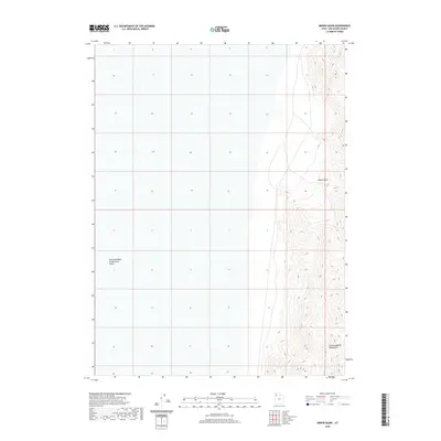
2020 Map of Miners Basin
USGS Topo · Published 2020About this map
Newfoundland Mountains dominate the eastern edge of this isolated landscape, rising sharply from the surrounding flats. The quadrangle is characterized by the vast expanse of the Newfoundland Evaporation Basin, a stark hydrological feature that defines the local geography. Within the mountain range, Miners Basin suggests a history of localized geological interest or extraction, though the modern survey emphasizes the physical contours and wilderness character of the region rather than dense settlement. The topography here is dictated by the dramatic shift from the flat basin floor to the steep, complex ridges of the desert mountains, providing a clear view of the Great Salt Lake Desert's interior drainage patterns and landforms as they were recorded in 2020.
Find a feature on this map
3 named features on this map. Tap any name to fly to it.
Don’t see what you’re looking for? This feature index may not catch every label — zoom into the map to look around manually.
Map Details
Editions of this 2020 Miners Basin Map
This is the sole edition of this map. No revisions or reprints were ever made.
Other maps of this area

1954 · Brigham City
USGS Topo · 1:250,000

1958 · Brigham City
USGS Topo · 1:250,000

1962 · Brigham City
USGS Topo · 1:250,000

1983 · Desert Peak
USGS Topo · 1:24,000

1983 · Lemay
USGS Topo · 1:24,000

1983 · Bovine SE
USGS Topo · 1:24,000
1983 · Big Pass
USGS Topo · 1:24,000

1983 · Groome
USGS Topo · 1:24,000

1983 · Lucin 4 NE
USGS Topo · 1:24,000
1983 · Keller Well
USGS Topo · 1:24,000