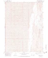
1983 Map of Miners Basin
USGS Topo · Published 1983About this map
Newfoundland Mountains rise sharply out of the surrounding Mud Flat in this 1983 topographic survey of western Box Elder County. The landscape is defined by the stark transition from the level alkaline plains to the steep, rocky slopes of the range, where the concentration of activity centers on resource extraction. Industrial history is evident in Miners Basin, where several Mines are clustered near the landmark USLM No 1. The terrain is sparse, with a lone Spring providing a rare water source and a Jeep Trail winding through the basin, offering the only improved access into the high ground. This map provides a clear record of the remote mining claims and geological surveying markers used during the late twentieth century in this isolated section of the Great Salt Lake Desert.
Find a feature on this map
10 named features on this map. Tap any name to fly to it.
Don’t see what you’re looking for? This feature index may not catch every label — zoom into the map to look around manually.
Map Details
Editions of this 1983 Miners Basin Map
This is the sole edition of this map. No revisions or reprints were ever made.
Other maps of this area

1954 · Brigham City
USGS Topo · 1:250,000

1958 · Brigham City
USGS Topo · 1:250,000

1962 · Brigham City
USGS Topo · 1:250,000

1983 · Desert Peak
USGS Topo · 1:24,000

1983 · Lemay
USGS Topo · 1:24,000

1983 · Bovine SE
USGS Topo · 1:24,000
1983 · Big Pass
USGS Topo · 1:24,000

1983 · Groome
USGS Topo · 1:24,000

1983 · Lucin 4 NE
USGS Topo · 1:24,000
1983 · Keller Well
USGS Topo · 1:24,000