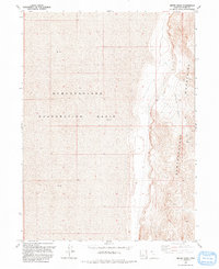
1991 Map of Miners Basin
USGS Topo · Published 1991About this map
The Newfoundland Mountains rise sharply above the stark expanses of the Newfoundland Evaporation Basin, defining a landscape of extreme contrast in western Box Elder County. This 1991 survey illustrates the remote industrial and geological character of the region, where extensive areas of Mud surround the high ground. The eastern slopes are marked by extraction history, centered on the Miners Basin district. Dozens of Mines dot the rugged topography alongside specialized survey markers like USLM No 1. Infrastructure in this arid environment is sparse but critical, represented by a Water Tank and a single Spring tucked into the mountain folds. The map documents the physical isolation of these peaks, which served as a desert island for prospecting and mineral exploration within the salt flats.
Find a feature on this map
8 named features on this map. Tap any name to fly to it.
Don’t see what you’re looking for? This feature index may not catch every label — zoom into the map to look around manually.
Map Details
Editions of this 1991 Miners Basin Map
This is the sole edition of this map. No revisions or reprints were ever made.
Other maps of this area

1954 · Brigham City
USGS Topo · 1:250,000

1958 · Brigham City
USGS Topo · 1:250,000

1962 · Brigham City
USGS Topo · 1:250,000

1983 · Desert Peak
USGS Topo · 1:24,000

1983 · Lemay
USGS Topo · 1:24,000

1983 · Bovine SE
USGS Topo · 1:24,000
1983 · Big Pass
USGS Topo · 1:24,000

1983 · Groome
USGS Topo · 1:24,000

1983 · Lucin 4 NE
USGS Topo · 1:24,000
1983 · Keller Well
USGS Topo · 1:24,000