1971 Map of Miners Canyon
USGS Topo · Published 1974About this map
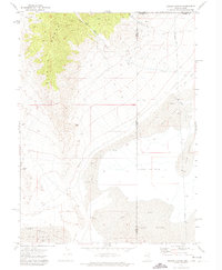
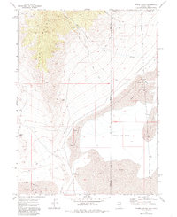
The Pilot Range dominates the western horizon of this 1970s landscape, where the high desert terrain of the Nevada-Utah border transitions into the vast Alkali or Mud flats. This survey documents a complex system of water management and natural springs crucial to the arid region, featuring an Aqueduct that skirts the foothills and several isolated water sources such as Miners Spring and Little Salt Spring. The presence of numerous Caves and the distinctive Window Rock suggests a geologically diverse environment that has long served as a landmark for those traversing the Pilot Creek Valley. East of the mountains, the terrain shifts dramatically into expansive Sand Dunes and the seasonal wetlands of Halls Meadow, illustrating the stark contrasts of the Great Basin's hydrography. The map also delineates the precise meeting of Elko, Tooele, and Box Elder counties at the state line.
Find a feature on this map
22 named features on this map. Tap any name to fly to it.
Don’t see what you’re looking for? This feature index may not catch every label — zoom into the map to look around manually.
Map Details
Editions of this 1971 Miners Canyon Map
2 editions found
Other maps of this area

1953 · Tooele
USGS Topo · 1:250,000

1954 · Brigham City
USGS Topo · 1:250,000

1955 · Tooele
USGS Topo · 1:250,000

1955 · Wells
USGS Topo · 1:250,000

1955 · Elko
USGS Topo · 1:250,000

1958 · Wells
USGS Topo · 1:250,000

1958 · Elko
USGS Topo · 1:250,000

1958 · Brigham City
USGS Topo · 1:250,000

1961 · Wells
USGS Topo · 1:250,000

1962 · Elko
USGS Topo · 1:250,000