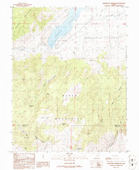
1986 Map of Minersville Reservoir
USGS Topo · Published 1986About this map
Mineral Mountains and the Black Mountains converge in this high-desert survey of southwestern Utah, where the Beaver River flows into the Minersville Reservoir. By the mid-1980s, the area had developed into a significant water management and leisure hub, marked by the State Recreation Area and various Boat Ramps along the reservoir's eastern shore. The landscape is defined by its water distribution network, including the Aberdare Canal skirting the Greenville Bench to the north.
Find a feature on this map
31 named features on this map. Tap any name to fly to it.
Don’t see what you’re looking for? This feature index may not catch every label — zoom into the map to look around manually.
Map Details
Editions of this 1986 Minersville Reservoir Map
This is the sole edition of this map. No revisions or reprints were ever made.
Other maps of this area

1885 · Beaver
USGS Topo · 1:250,000

1953 · Minersville
USGS Topo · 1:24,000

1953 · Cave Canyon
USGS Topo · 1:24,000

1953 · Richfield
USGS Topo · 1:250,000

1958 · Richfield
USGS Topo · 1:250,000

1958 · Minersville
USGS Topo · 1:62,500

1958 · Beaver
USGS Topo · 1:62,500

1958 · Adamsville
USGS Topo · 1:62,500

1971 · Buckhorn Flat
USGS Topo · 1:24,000
1971 · Greenville Bench
USGS Topo · 1:24,000