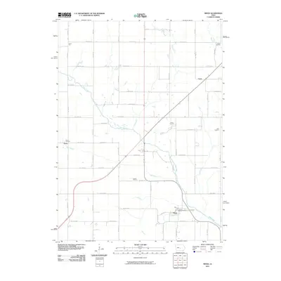
2010 Map of Mingo
USGS Topo · Published 2010About this map
Mingo serves as the primary hub of this Iowa landscape, where the Mingo Post Office anchors a rural grid defined by agricultural sections and creek drainages. The terrain is deeply tied to the path of Indian Creek and Wolf Creek, which flow southward through the quadrangle. Small, scattered settlements like Farrar, Clyde, and Peoria City mark the intersections of county roads, representing the enduring structure of Jasper County's farming communities. For genealogists, the map is particularly valuable for its documentation of local burial sites, including the Ashton Cemetery, Graham Cemetery, and Dieter Cemetery. These landmarks, along with Kintz Cemetery and Farrar Cemetery, provide a clear spatial record of the area's early families. The road network, including CTY f17, overlays a landscape where smaller water features like Byers Branch and Clear Creek continue to shape the local geography.
Find a feature on this map
59 named features on this map. Tap any name to fly to it.
Don’t see what you’re looking for? This feature index may not catch every label — zoom into the map to look around manually.
Map Details
Editions of this 2010 Mingo Map
This is the sole edition of this map. No revisions or reprints were ever made.
Other maps of this area

1930 · Mitchellville
USGS Topo · 1:62,500

1954 · Des Moines
USGS Topo · 1:250,000

1956 · Des Moines
USGS Topo · 1:250,000

1957 · Des Moines
USGS Topo · 1:250,000

1965 · Colfax
USGS Topo · 1:24,000

1969 · Des Moines
USGS Topo · 1:250,000
1972 · Altoona
USGS Topo · 1:24,000
1972 · Mitchellville
USGS Topo · 1:24,000
1972 · Loring
USGS Topo · 1:24,000

1975 · Mingo
USGS Topo · 1:24,000