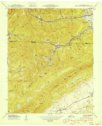
1950 Map of Mingo Mountains
USGS Topo · Published 1950About this map
Log Mountains and the Mingo Mountains dominate this 1950 topographical study, revealing the deeply industrial and communal character of the Kentucky-Tennessee border. Small coal-driven settlements like Fork Ridge, Bryson, and Manring are connected by the L & N railroad lines that snake through Mingo Hollow and the Clear Fork valley. These communities, often located at the base of steep spurs like Moseley Spur and Whiteoak Spur, were supported by local institutions such as Union School and Monarch School.
Find a feature on this map
81 named features on this map. Tap any name to fly to it.
Don’t see what you’re looking for? This feature index may not catch every label — zoom into the map to look around manually.
Map Details
Editions of this 1950 Mingo Mountains Map
This is the sole edition of this map. No revisions or reprints were ever made.
Other maps of this area

1886 · Cumberland Gap
USGS Topo · 1:125,000

1888 · Cumberland Gap
USGS Topo · 1:125,000

1891 · Cumberland Gap
USGS Topo · 1:125,000

1897 · Maynardville
USGS Topo · 1:125,000

1900 · Maynardville
USGS Topo · 1:125,000

1903 · Middlesboro
USGS Topo · 1:48,000

1927 · Middlesboro
USGS Topo · 1:62,500

1930 · Middlesboro
USGS Topo · 1:62,500

1935 · Mingo Mountains
USGS Topo · 1:24,000

1935 · Cumberland Gap
USGS Topo · 1:24,000