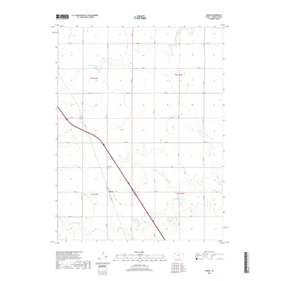
2018 Map of Mingo
USGS Topo · Published 2018About this map
Mingo serves as the focal point of this Thomas County landscape, situated where the grid of county roads meets the diagonal cut of the highway. The settlement's history is anchored by the Mingo Cem, a key landmark for local genealogical research located just north of the town center. The terrain is defined by the high plains drainage system, with the N Fork Solomon River crossing the northern sections and the S Fork Solomon River winding through the southern reaches. This 2018 survey reveals a landscape almost entirely dictated by the Public Land Survey System, where a precise network of routes like Co RD 24 and Co RD K divide the territory into regular sections, illustrating the enduring agricultural organization of Western Kansas.
Find a feature on this map
23 named features on this map. Tap any name to fly to it.
Don’t see what you’re looking for? This feature index may not catch every label — zoom into the map to look around manually.
Map Details
Editions of this 2018 Mingo Map
This is the sole edition of this map. No revisions or reprints were ever made.
Other maps of this area

1943 · Colby
USGS Topo · 1:62,500

1954 · Goodland
USGS Topo · 1:250,000

1956 · Goodland
USGS Topo · 1:250,000

1957 · Goodland
USGS Topo · 1:250,000

1967 · Colby SE
USGS Topo · 1:24,000

1967 · Colby
USGS Topo · 1:24,000

1972 · Winona NE
USGS Topo · 1:24,000
1979 · Mingo
USGS Topo · 1:24,000

1979 · Oakley North
USGS Topo · 1:24,000
1979 · Gem
USGS Topo · 1:24,000