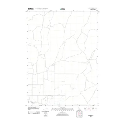
2010 Map of Minidoka
USGS Topo · Published 2010About this map
Minidoka anchors the southwestern corner of this landscape, serving as a primary point of settlement within a region defined by a precise grid of rural thoroughfares. The road network, including 1000 North Rd and 1000 East Rd, illustrates a transition from the structured agricultural or utility allotments in the south to the more winding, topographic-responsive routes further north. Significant transit corridors such as the Minidoka To Arco Rd and Arco Rd provide essential connections through the high desert terrain, linking the small community to more distant regional centers. This 2010 U.S. Geological Survey representation reflects the modern infrastructure of the Snake River Plain, where named routes like Yale Rd and Desert Rd delineate the vast, open spaces characteristic of this part of southern Idaho.
Find a feature on this map
8 named features on this map. Tap any name to fly to it.
Don’t see what you’re looking for? This feature index may not catch every label — zoom into the map to look around manually.
Map Details
Editions of this 2010 Minidoka Map
This is the sole edition of this map. No revisions or reprints were ever made.
Other maps of this area

1954 · Pocatello
USGS Topo · 1:250,000

1958 · Pocatello
USGS Topo · 1:250,000

1959 · Lake Walcott
USGS Topo · 1:62,500

1964 · Acequia
USGS Topo · 1:24,000

1972 · Schodde Well
USGS Topo · 1:24,000

1972 · Bear Trap Cave
USGS Topo · 1:24,000

1972 · Minidoka
USGS Topo · 1:24,000

1972 · Max
USGS Topo · 1:24,000
1972 · Brigham Point
USGS Topo · 1:24,000
1972 · Larkspur Park
USGS Topo · 1:24,000