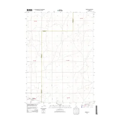
2013 Map of Minidoka
USGS Topo · Published 2013About this map
Minidoka sits at the southwestern edge of this high-desert landscape, where the street grid of the small community meets a vast network of section-line roads and drainage patterns. The map highlights the intersection of local life and county governance, with the Minidoka Co Blaine Co boundary line cutting across the sagebrush and lava-scarred terrain. Local infrastructure is concentrated in the settlement along Broadway St and Cherry St, transitioning quickly into a sparse agricultural and desert landscape to the north and east. The layout of the region is defined by long, straight thoroughfares like Desert Rd, Arco Rd, and Yale Rd, which facilitate movement through the high plains. This 2013 survey provides a detailed record of the township and range divisions that have historically organized this part of Idaho, showing the clear transition between developed town plots and the open desert range.
Find a feature on this map
21 named features on this map. Tap any name to fly to it.
Don’t see what you’re looking for? This feature index may not catch every label — zoom into the map to look around manually.
Map Details
Editions of this 2013 Minidoka Map
This is the sole edition of this map. No revisions or reprints were ever made.
Other maps of this area

1954 · Pocatello
USGS Topo · 1:250,000

1958 · Pocatello
USGS Topo · 1:250,000

1959 · Lake Walcott
USGS Topo · 1:62,500

1964 · Acequia
USGS Topo · 1:24,000

1972 · Schodde Well
USGS Topo · 1:24,000

1972 · Bear Trap Cave
USGS Topo · 1:24,000

1972 · Minidoka
USGS Topo · 1:24,000

1972 · Max
USGS Topo · 1:24,000
1972 · Brigham Point
USGS Topo · 1:24,000
1972 · Larkspur Park
USGS Topo · 1:24,000